Hi all - finally got the Cape Reinga Tramp blogs and photos all up - hope you enjoy them :)
In the meantime we've been on the Great Barrier Island for a week and half, and will hopefully have our soggy adventures there posted soon!
Next we're headed south for some caving, geothermal areas and of course more beautiful coastline...

Friday, June 27, 2008
Cape Reinga Tramp Day 4: No Longer Beasts of Burden
I wake up in the early pre-dawn and lie quietly in my sleeping bag. Christina is still asleep. Through the mosquito netting that makes up half of our tent, I see at least a couple of dozen mosquitoes buzzing about quietly, hiding under the rain fly. They drift back and forth across the netting, trying desperately to get into the tent. I suppose the heat which we are putting off is visible to them from that distance and that they have spent the whole night wandering back and forth searching for a door into bloodsucker's paradise.
With true dawn comes the chorus of a few birds. The mosquitoes eventually go away, and we strike camp, eat a few more cereal bars, then walk on the beach. It's a gorgeous, sunny morning and I can almost forget just how disgusting I feel after sweating and stumbling through the muck for the last 3 days.
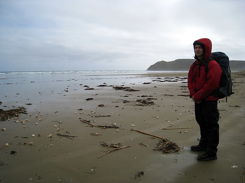
It's nearly noon, so we head back to the park entrance and wait for our ride. He shows promptly, and it's back to Waitiki Landing. We clear up the bill, buy an ice-cream cone, then are off down the Peninsula as reasonably fast as the van will go, glad to be driving and not walking the 100+ kilometers.
With true dawn comes the chorus of a few birds. The mosquitoes eventually go away, and we strike camp, eat a few more cereal bars, then walk on the beach. It's a gorgeous, sunny morning and I can almost forget just how disgusting I feel after sweating and stumbling through the muck for the last 3 days.
It's nearly noon, so we head back to the park entrance and wait for our ride. He shows promptly, and it's back to Waitiki Landing. We clear up the bill, buy an ice-cream cone, then are off down the Peninsula as reasonably fast as the van will go, glad to be driving and not walking the 100+ kilometers.
Cape Reinga Tramp Day 3: These Boots were (not) made for Walking (in the Sand)
06Jun08
Dawn comes way too early. I've set the alarm for 6:30 a.m., and we drag ourselves up, put on the same stinky clothes we've been living in for the last few days, and strike camp.
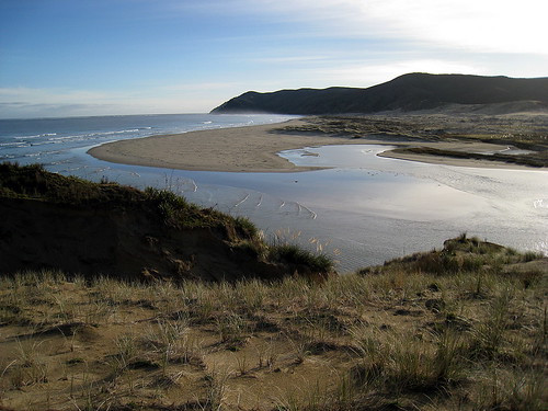
At around 7am we are looking at the estuary. It's higher than it was when we first looked at it last night, and we walk upstream, searching for the crossing point casually mentioned in the track description. Following the muddy ruts of a jeep track, we eventually come to a place where they bear sharply left across the sand and into the rising water.
It's the usual routine - roll-up trousers, take off shoes, and wade. The periodic "incoming tide" waves roll slowly upstream while we do this, cresting the current edge of the estuary and lapping at the sandy floodplain. We hurry across, wincing at the chilly water, pausing for a moment on a sandbar island, then going ashore.
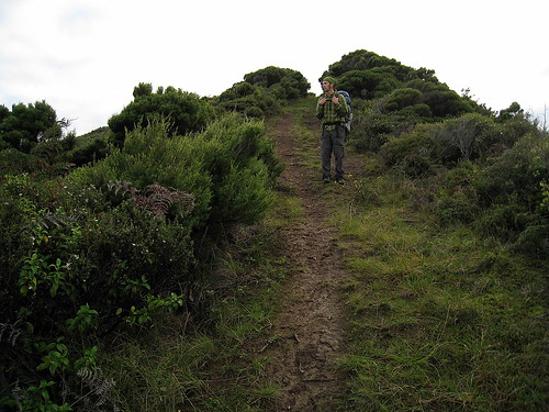
After hopping about for a minute forcing shoes back onto numb feet, we head inland on the boggy jeep trail. Around us rises the regenerating bush and the air is filled with the early morning chatter of birds. We begin to wonder if we're on the right path, but another 10 minutes brings us to a sign marking where the track branches off and leads up the mountain. We eat cereal bars and continue onward.
Lead up the mountain it does, and with no concern whatsoever for grade. The trail is a mountain goat track leading straight upwards at something like 60% grade. We huff and puff and almost crawl up the slope, covering in 30 minutes what is supposed to take nearly an hour.
By the end we are seriously out of breath, but pleased with ourselves, until we inspect the part of our forward path which this higher vantage point has brought into view.
We have a long, long day of ridgeline ascents and descents, and there's nothing for it but to keep walking. Below us the estuary we crossed is more than twice as wide as it was when we passed it and growing steadily.
We stop and drink some hot tea, then continue along the ridgeline in a somewhat more gentle ascent. Fantails flutter around us, snapping up tiny insects that we are stirring up, but refuse to sit still long enough for Christina to take a decent picture.
For the rest of the morning. We trudge up and down through magnificent views. At some point ahead, the trail branches. One fork leads down to Pandora Beach; the other leads upwards to Te Paki mountain, the highest point in Northland. It's actually only perhaps 100 meters higher than what we've been climbing for the last couple of days, but even though there's supposed to be some interesting remains from a wartime radar installation, as well as gorgeous views, we are not in the mood to add another hour to a day already full of walking.
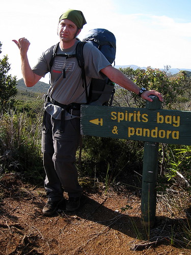
Eventually we round a corner, come down a ridge, and see the turnoff sign for Pandora Beach! Even though we have a long ways to go, it feels like we're home free. There will be no more serious ascents on the tramp, and our legs are glad.
Pandora Beach used to be a resort, and we are following the heavily eroded dirt road that once led to it. The bush gets thicker and thicker as we descend. Hopping over gullies and slopping through mud puddles, we near the bottom of the road. In the bush as we are, it's impossible to see the ocean until we round the last corner, though the sound of the stream paralleling the bottom stretch of the road gradually merges into the roar of the surf, letting us know we are nearing the beach.
The road dead-ends in an overgrown pasture-swamp. There's a worn sign on the gateway telling us where we are. Its back is a sign painted for a different location. Evidently the park is not into wasting money on new signs. The grass choking the meadow is a mass of tangled roots and runners over a foot deep on top of trickling water everywhere. It's thick enough to keep our feet out of the muck for the most part, but the 3-foot high scrub we have to push through makes for slow going.
We wander about, looking for the best path through the grass, and eventually make our way onto the actual beach.
It's absolutely deserted, and we toss our bags under a tree and against the rocky bluffs, then wander out through the surf for a few minutes, letting the cool water soothe our aching feet.
We eat a belated lunch - sausage, crackers, apples - under the tree, watching the surf roll in. We feel completely like not moving again. With our backs against the warm rocks and our feet out in the sun, it's almost possible to forget how tired and grimy we are.
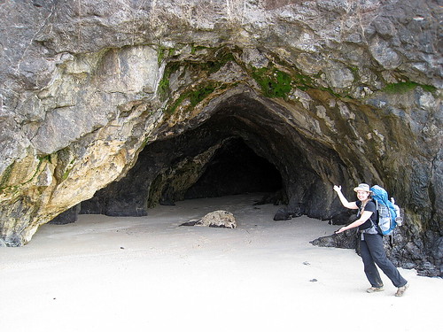
To the east, some thunderheads threaten, and we drag ourselves to our feet, shoulder our packs, and walk east along the beach to the final tide-dependent part of the path. There's a rocky headland separating Pandora Beach from Spirits Bay, and at low tide it is possible to walk around it. At high tide it's necessary to climb up and over a couple of headlands. We are very tired of climbing. Though we're a couple of hours before low tide, the crossing is relatively easy. We peer into a couple of exposed caves in the rock as we wind our way over to Spirits Bay.
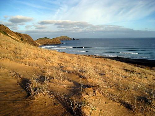
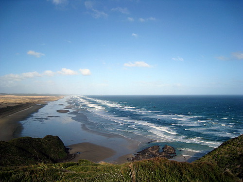
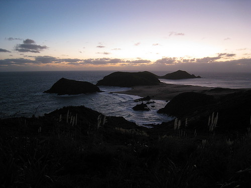
Spirits Bay is gorgeous - it's a long, gentle, sandy curve, cupping the Pacific ocean and backed with sand dunes merging into green rolling hills.
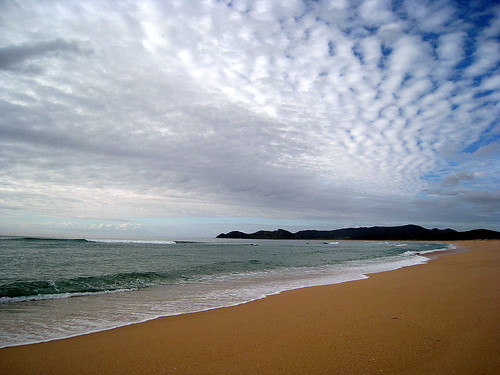
The operative word in that description is long, for though it doesn't seem like it should take so much time to walk, 5 miles in sand turns out to be slow going. We pass the time by picking out random landscape features as distance markers along our path. Half-way, two-thirds, three-fourths, and then we are done.
The beach is, as usual, gorgeous - I'm not sure I've seen ugly coastline in NZ - but we are almost numb to its beauty by the end. The sunset over the sea , however, wakes us back up, with brilliant orange, yellow, and red hues filtering through the black-blue clouds. To the east, the clouds over the ocean hang purple shot through with crimson, and behind us, to the south, the clouds are glowing pink and fringed with blue.
Finally, we see a pair of figures at the end of the beach, and realized that we've reached the campground. It's a couple of guys setting up at the spot nearest the ocean, and we make our way inland a couple of hundred meters before dropping our gear and proclaiming ourselves home for the night.
Cape Reinga Tramp Day 2: Dolphins, Lighthouses, and Rubber Legs
05Jun08
day 2 photo set
day 2 photo set
We drag ourselves up as early as we can. I set the alarm for 5:45, but as it's not even dawn til 7am, we don't drag ourselves up for an hour. 2 more alarms do little to stoke our enthusiasm. Stuffing tent and bags into our packs, we trudge forward, eating cereal bars and hurrying towards our first water crossing.
In daylight, the next marker, the one we could not find last night, is blatantly obvious, and we trudge along the trail as rapidly as we are able. Our shoulders hurt from the heavy packs and poorly adjusted straps of yesterday. We're still in the sand dunes and coastal, beach-grass covered hills. The path continues to be nothing more than untracked dunes, rosy-tinted in the early morning sun, and regular orange-capped signposts. Behind us lies Cape Maria Van Diemen with its twin (old and new) lighthouses. We parallel the coast for a ways, following the trail along the top of the hills. A pod of dolphins pops to the surface periodically in the cove below us.
We resist clambering down to the beach for a closer look and continue up and over the next low headland, coming at last into sight of the estuary. It's well after 7am, and the tide is coming in fast. From our vantage point high on a bluff, the estuary doesn't look rough or deep, except perhaps at its mouth. We follow the trail over to where the usual crossing would be, but the climb down to the water is more difficult than expected and the incoming surf is stronger than anticipated.
Backtracking inland, we make our way through a swamp to an easier crossing spot. Thankfully it's relatively calm here. We wade across the cold waterway and pause upstream to refill our water bottles.
It's our first field-test of the water filter, and it seems to perform admirably. We get a pot of tea going, and then stock up on water. Meanwhile a pied shag wanders by and checks us out, followed by a small flock of ducks. We barely get the water bottles filled before a strong tide sweeps up the estuary and over its banks, nearly swamping our equipment. We move uphill a few feet, then sit and drink our tea. The occasional strong tide seems to come every 5 minutes or so, and I wonder at the reasons for its apparent periodicity.
After finishing our tea, we climb back to our feet, refreshed, and head down Te Werahi beach. It's quite pretty, but by the end, we are once again tired of walking on a beach.
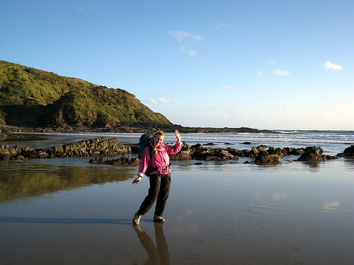
At the end of the beach we are confronted with our second tide-dependent water crossing of the day. The trail up to Cape Reinga lighthouse leads around the tall bluffs on the west edge of the headland and up a steep track. Perhaps at low tide one could walk casually to this part of the trail, but now it's necessary to thread our way up and down over large slippery rocks and outcrops, and to time our crossings so as not to be swamped by the larger waves. Christina loses her balance and crashes down early on, then gets caught by an eager wave and half-soaked. I get a little wet, but nothing like Christina. Regardless, she carries on without complaint and we eventually make our way to the protected inlet at the bottom of our coming steep climb. The air is thick with the stench of rotting kelp, and we regroup hurriedly, then begin the ascent.
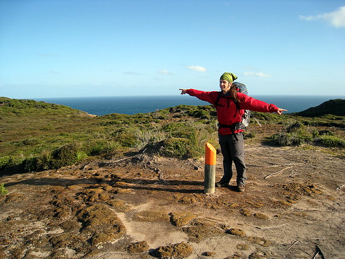
It's a steep climb and we are both ready for a break. The original trampers must have had iron muscles and an unending appetite for views. Every leg of the tramp is either along the top of a 1000-foot ridge or a steep ascent towards or away from one. After a time we come into hearing and sight of the Cape Reinga lighthouse park. A group of schoolkids is up there yelling and running and generally having a good field trip. It's all rather surreal after the last couple of days. Bus rides and teachers and packed bologna lunches seem a million years ago at this point.
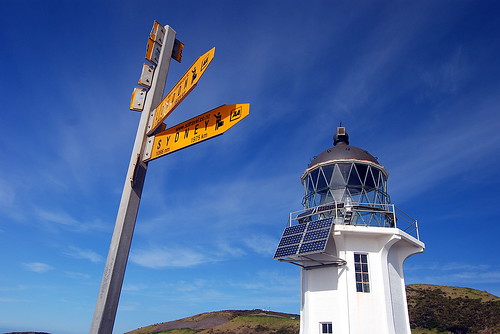
Finally we climb up the last switchback of the trail and arrive at the restrooms. We walk over to the park map signs and sit on the grass to eat lunch and look out at the ocean. A few minutes down a narrow paved road, the schoolkids ruckus around the Cape Reinga lighthouse.
We chew through part of a big stick of pepperoni and some crackers while the occasional tourist or schoolkid wanders curiously past. By the time we are done with lunch, the lighthouse is almost deserted. We walk down to it and read the signs, take a few pictures, and look out at the endless ocean. Below us on the last bit of land is the tree where Maori believed their ancestors went to jump off to the netherworld when they died. Here, too, the Pacific and Tasman seas meet. The ocean is very rough, and the sight of one set of waves crossing paths at almost right angles to another set of waves is startling.
After a few minutes we walk slowly back up the road. At the top, we pass a couple of people from a construction crew. The whole Cape Reinga site is being redesigned. The car park and the restrooms are being moved, and we struggle to find the starting point for the rest of the trail. Eventually we run into the same construction crew, who point out the half-hidden entrance. Meanwhile a german couple pauses to ask us how long it takes to walk down to Te Werahi, as they are interested in camping. We give honest answers and urge them to be careful with the tides.
We are on our way out of the car park and down from Cape Reinga. The surrounding hills are steep and thick with regernating bush. It's late in the day and we hurry in the fading reddish light. The whole world is that rosy hue it turns sometimes before sunset. Our legs are weary and we stumble down the steep ridgeline towards our campsite on Tapotupotu Beach.

We turn inland for perhaps a hundred meters, walk through dank brush, and come into the campsite in the growing dusk.
It's a regular DOC campsite. There's a road to it and a couple of campervans already parked. We struggle up the road to the tent sites, drop our bags, then investigate the facilities. The usual long drop and non-potable water supply round out our list of luxuries for the night. We eye the tidal estuary in the middle of a huge sand bar. It's our first challenge for the morrow. I put up the tent while Christina rummages for our dinner. We barely manage to get these tasks done before collapsing, and determine that cooking chicken curry noodles in our tent - no matter how bad the mosquitoes - is always a mistake. I wander over to the estuary immediately east of the campsite and investigate how rapidly it's rising. In the dim glow from my flashlight, it's obvious that the intervening hour has added at least 50 feet to its width. Though the other campers twice invite us to join them at a bonfire on the beach, we decline. We have to cross the estuary early tomorrow and can barely keep our eyes open.
Cape Reinga Tramp Day 1: Sore Shoulders and Soggy Shoes
04Jun08
day 1 photo set
day 1 photo set
Wednesday begins a bit chilly and slightly overcast. Christina and I rustle up breakfast - eggs, cereal, and toast, and coffee - while we make a list of all the items to pack for the tramp. After cleaning up, we quickly stuff all of the necessary camping gear into our packs:
1 tent and associated stakes and such
2 sleeping bags
2 thin inflatable pads
a change of clothes apiece, plus extra socks.
fleece jackets and rain coats, plus rain pants.
chaco sandals
camp stove and 2 fuel canisters
food for 3 days
3+ liters of water and water filter
toiletries and camp shovel
maps and guidebooks
two cameras
(etc.)
Our packs are now considerably heavier than anything we've ever hiked with before, but we shoulder them on and head up to the Waitiki Landing office to catch our ride. It's a few minutes after 10am, and no one is in the office. A moment after we get there, a Maori lady pops out from the adjacent fuel station/quick-stop and tells us that she's to drive us to our drop-off point today, but asks us to wait for a minute while she grabs some belated breakfast. Breakfast today is apparently a bag of crisps, a microwaved "hot pocket", and a large mug of tea with milk. Within 10 minutes, the man whom we originally arranged the trip with drives up in a 4WD van and we clue in to the fact that she is his wife. He agrees to take us straight-away in order to speed up matters.
Our ride to the drop-off point is uneventful. We heave our packs in the back of the van and are soon speeding out towards the west coast at a rather startling rate. After a kilometer or so on pavement, we skid onto a muddy, potholed gravel drive and continue without loss of speed around blind corners, over 1-lane bridges, and on the edge of sharp drop-offs - sometimes in our lane, sometimes in the middle of the road, depending on what is necessary to make the next turn without slowing down. Only the appearance of a fully-loaded logging truck - both trailers sagging under its cargo of pine - barrelling towards us over a 1-lane bridge occasions a full stop on our part.
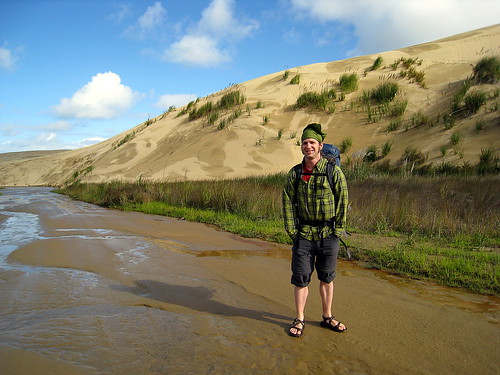
15 minutes and we we reach the drop-off point at the end of a muddy track. Between us and the Tasman Sea are a few kilometers of tall sand dunes, cut through by Te Paki stream, the shallow, sandy river that constitutes the first part of our hike. Our driver wishes us well as we reclaim our packs, promises to pick us up in 4 days time, then zips off to whatever task awaits him. We make use of the nearby DOC long drop, put on our sandals and roll up our pants. Meanwhile a local woman shows up in a van and sets up shop, waiting for the off-season sand-surfing enthusiast. It's the first I've heard of the sport, but Christina informs me that it's popular in NZ to rent body-boards and ride down the sand dunes.
The day is still moderately sunny, but within half an hour of our start, blue-gray clouds begin rolling in from the west. I begin to regret my decision not to purchase a pack cover. We continue walking very slowly, slogging through the shallow water and saturated sand, trying to figure out how to best adjust our pack straps. To our north, the sand dunes continue out of sight. To our south and east, the dunes are bordered by rolling green hills. It's still a pretty day, but the original strong breeze is now turning rapidly into a serious headwind. A gentle rain begins to fall. At the point, the wide, shallow stream is little more than a set of intersecting rivulets, perhaps 20 meters wide, criss-crossing the flat sand towards the ocean. We meet a car driving upstream; its inhabitants wave cheerily at us as it passes. We ponder its fate in the heavier, less stable sand upstream and mentally wish them luck. Looking back as they pass, we see from the paint job that it's a rental car, so whoever is driving it has been doing their best to ignore the clause in all rental vehicle contracts which forbids you from driving on 90-mile beach. According to what we've been told (again and again), vehicles quite regularly get stuck in the sand and then dragged under by high tide.
As we come around a curve and into sight of the Tasman Sea, the rain begins to fall more steadily. We trudge on, but by the time we pass the last dune, we're walking in a downpour. At this point we realize the first lesson of rain gear, which is that you put it on *before* you are caught in the rain. We drag out our jackets and rain pants and weasel our already-soaked selves into them, then huddle behind the last sand dune for the meager shelter it affords from the wind.
Today we are lucky; the rain dwindles to a fine mist after perhaps only 20 minutes or so, and we sit amidst the beach-grass and gorse and eat half-squashed peanut butter and jelly sandwiches.
Lunch concluded, we set off north along 90-mile beach. The sky is still thick with clouds, and periodically the heavy mist turns into light rain, but never into the sort of downpour just experienced. To our west the Tasman Sea roars and crashes onto the sand. It's a far cry from the gentle waves we saw just a few days ago at Matauri Bay. The beach is littered with shells, driftwood, kelp, the occasional dead fish, and small bits of the kind of industrially-manufactured flotsam you find on every beach - plastic bottles, short lengths of net, etc. The surf is loud enough to make conversation difficult, and for the most part we trudge northward in silence. Near the end of the beach, we are passed by a small truck heading north. It stops perhaps a kilometer beyond us and picks up someone, then turns around and passes us going back south. The driver waves cheerily and then we are alone. Behind us a great arch of rock to our south in the sea seems almost to be following us as we walk - closer one moment, then further away the next.
At the north end of the beach, the trail climbs up a very steep set of stairs for a few hundred meters, zig-zagging back and forth up the rock. We pause for a moment at its base to adjust packs and drink some water, then begin our ascent. This initial climb sets the pattern for our next few days, which is one of continual steep ascents followed by steep descents, punctuated by regular high ridgeline walks. It's a path designed to maximize spectacular views without any concern for one's legs or back. Out at sea, white-capped wave follows white-capped wave in unending succession.
From the top of that first headland we look out and around the world. To our north and west lie the Tasman /Sea, crashing on the shore of Twilight Beach. To our east rises Cape Maria van Dieman and beyond that Cape Reinga. To the immediate south lie rolling half-grassy dunes such as we have been paralleling on our walk northward. The southeast, incourogously, is all gentle green hills dotted with sheep and cattle. It's mid-afternoon, and we still have a long way to go.
Before we start forward again into the brush, we note a pair of figures slowly toiling down the beach, perhaps half an hour behind us. Walking through the brush is not really that exciting. When you can't see very far ahead or behind you, and when the view to either side is blocked, points of interest are limited. The birds seem to agree. Either it is the universal naptime or anything which can fly aside from a few bugs has left for more stimulating environs. Periodically we emerge from brush near the top of some hill and gaze out at the ocean, only to lose it moments later as we plunge down 50 hard earned meters of altitude. It's obviously rained recently, for the whole track is muddy. The lowest spots are actually car-sized mudholes, and squeezing by these is difficult, since the woody brush is thick enough to prevent easy passage. Perhaps with a chainsaw it might be straightforward, but not without. Here and there the undergrowth becomes thicker. Frequently these spots are accompanied by a musky stench which I suppose must be wild pigs, as the path is punctuated by torn-up patches of earth where something has been rooting and digging..
The brush we are walking through is criss-crossed by tracks. Whenever ours intersects with another track, an orange marker points out the correct direction.
Some of the other trails look enticing, but without a map, navigation in brush several feet taller than our heads seems like a bad idea. The track we are walking on at some points was obviously some sort of rough driving track, but it's been years since anything larger than a quad-bike has driven this way. The gullies and crevices which cross the narrow track would bog down anything larger.
An hour or so into the brush, we are ready for a break. It's very humid and still, and in the middle of the day we are nearly drowning in our own dank sweat. Shrugging off our packs and collapsing on the trail, we munch on peanuts and chocolate. There is really no other place to sit other than the least wet patch of muddy rock, and at this point we don't care. In a minute, the sound of voices becomes audible, and the young couple who must have been trailing us back on the beach comes around the corner. They smile, say hello, and carry on. We wish them well, then glance at their cheery faces and lightweight packs as they pass. How are they getting by? Perhaps it's all cold dehydrated food for them on this tramp, or maybe they're just in for a day, or maybe they don't feel the need to carry the kitchen sink on their backs around NZ.
After a few more minutes we struggle to our feet, adjust our pack straps for what seems like the millionth time, and set out. Shortly thereafter we are rewarded with a grand view to the southeast over the verdant texture of the bush-coated hills and a sight of our trail looping down towards Twilight Beach, which marks the official end of our first day's tramp. A bit heartened, we stomp down over the eroded track - which at this point was definitely at one time a rough bush road - and towards the beach. Having come out of the shadowy, overhanging scrub and buoyed by a bit of sunshine and receding claustrophobia, we decide if possible to push onward past the planned campsite and take the first of many water crossings.. It's nearing low tide, and according to the DOC brochure, we need to attempt this crossing within an hour either side of low tide.
Over a couple of hills and down we go! An hour passes and we reach the beach. It's sunny and beautiful in the waning daylight, and we trudge hurridly down the sand. Twilight Beach doesn't seem that long, but it's the described 45 minutes before we reach the east end. By this point, the sun hangs low on the horizon, casting blue and purple shadows on Cape Maria Van Dieman to our east. We wander about at the end of the beach and finally find the marker pointing the way up towards the official campground. If we'd only followed our noses, we would have known where to go, since the path off the beach is marred by a distinctly bathroom odor. Why the prior hordes of trampers all chose to pee so close to the track remains a mystery.
We climb up and up until we find the next set of signs. They mark the intersection between our tramp and another trail leading back towards the farmland to our south. We continue on, following the orange-topped posts which mark the path, and climb higher, passing the couple we met earlier. They are busy pitching their tent in the waning light, high up on a grassy protected meadow. Over one hill and another and then we are walking in the dusk. We've left behind the grassy hills and are now struggling across sand and eroded rock. The growing wind whips up the sand, and we stumble repeatedly, our feet caught by the immensely long runners of the grass which seems to be holding together this corner of New Zealand. The sky is dark, and in the twilight, the dunes and bluffs are that weird, barely-colored reddish-purple that meets your eyes before color vision gives up completely and the world turns gray.
Up again and we are walking behind a large sandy bluff, flashlight in hand, casting about for footprints or other signs of a trail. In the sand and on the rock, the only way to know you are on the trail is to see an orange marker at some random point ahead. A set of footprints is suggestive, but not a guarantee. Who knows where the person who made those was going? We persist until it's no longer possible to find another marker, then look for a place to camp for the night. The best we can manage is a spot behind a tiny, grass-topped hillock. It's the least-unlevel patch of sand in sight. We pitch the tent in darkness and wind, juggling flashlight and tent stakes, then crawl gratefully inside its shelter. Dinner is 2 packets of 'Pasta Carbonara', boiled hastily over our camp stove and shoveled down. Zipped into our sleeping bags, we fall asleep to the sussurration of the wind, the rustling of the grass above and behind us, and the endless crashing of the distant ocean.
Wednesday, June 11, 2008
Several New Posts and lots of pics
Hi All - another glut of posts has arrived :)
Read on about our exciting adventures at not so Hot Water Beach, auto salvage yards, artistic toilets, digging clams, beaches of paradise, and the start of our Cape Reinga Tramp!
And thanks for all the comments - keep 'em coming :) We don't have as much time to respond as we'd like, but we love reading them.
Cheers,
Christina and Justin
photostream is here
The Way to Waitiki Landing - Dogs and Mud
June 3, 2008
The drive up the Cape Reinga peninsula is quick but not spectacular. We drop back into Kaitaia to get supplies at the large Pak 'N' Save there, leaving our campervan rather nervously near the front entrance, as the Lonely Planet guide we are using cautions us against the likelihood of theft in the region and even in the parking lot of this very grocery store. Of course nothing eventful happens, and we stock up on food for our upcoming tramp, pick up some rather lackluster but cheap meat pies at a bakery, then drive back north up the peninsula.
The drive up the Cape Reinga peninsula is quick but not spectacular. We drop back into Kaitaia to get supplies at the large Pak 'N' Save there, leaving our campervan rather nervously near the front entrance, as the Lonely Planet guide we are using cautions us against the likelihood of theft in the region and even in the parking lot of this very grocery store. Of course nothing eventful happens, and we stock up on food for our upcoming tramp, pick up some rather lackluster but cheap meat pies at a bakery, then drive back north up the peninsula.
The peninsula itself is rather quiet. From the main highway, which sticks to the middle part of the land, it appears to be mostly grazing land, punctuated by the occasional pine plantation. These plantations come in 3 varieties: young and tender, tall and proud, and completely razed to the ground. Periodically we pass through what passes for local towns. Most of these are doing well to manage more than 5-10 houses, and in the late afternoon not much appears to be going on. The land itself is mostly low and rolling. Aside from the pine plantations, there aren't a whole lot of trees. The houses themselves are quite modest. Evidently the tourist and vacation-home driven development has not hit this area. I suppose the general lack of sunny beaches has something to do with that.
Near Te Kao, we round a corner and spy an enormous tawny hound at rest in the opposite lane. He lies there on the road with his head pillowed on his paws and watches us approach. I slow down a bit in case he is preparing to do something stupidly doglike, and am more richly rewarded than I could have dreamed, as at the last minute he leaps to his feet and attempts with great energy to throw himself under our front wheels. Swerving and braking, I squeak around him, his body hidden from sight by his closeness to our van, knowing I haven't smacked him mostly by the lack of audible or tactile *thump*s.
Looking in the rear-view mirror as we drive away, we see him standing in our lane looking after us with what I can only assume is a pleased expression. I suppose just like in horseshoes and hand grenades, 'close' to driving off the road counts as a success for the dog.
Christina marks the location of the dog on our map so we can watch for him on our trip back and we drive on. Near dusk we roll into Waitiki Landing, which is instantly familiar. It's the truck stop on the edge of nowhere, the last place to fill up on gas, catch a bite to eat, or buy what passes for essential groceries in this neck of the woods. There are several buildings arranged in kind of a compound. I back the van into a parking spot next to the preserved top of an old lighthouse (with dust and fly-spot covered sign proudly proclaiming its availability for regular display), and we walk into the room labeled 'office', calling out politely until someone appears.
A voice calls out: 'Just a minute.' Momentarily, a rough-boned man with weathered workman's hands walks in from a side door. He's amiable enough, and shortly we arrange to be dropped off the next morning, Wednesday, and picked up at the end of the tramp Saturday at noon. We also make camping arrangements for the night. He warns us that some of the spots are a bit soggier than others, waggling his eyebrows at us as he says this. I fail totally to clue in as to what level of emphasis eyebrow waggling constitutes.
We walk back to the van. The light is almost gone. Christina goes down to scout out the kitchen, bathrooms, and general layout of the campsites. I start the van back up and drive through the gate and down the slope onto the small grassy field. It's nearly dark by this point. I roll around a few sad trees - apparently no one at Waitiki Landing is much into landscaping - and towards a part of the field that appears flat enough to let us sleep without rolling or sliding on our bed. After a moment, I see Christina walking back towards me from another area across the gravel drive, so I turn towards her and pull to a stop as she reaches me. The squelching noise as I brake is my first clue that something unfortunate is happening.
Christina steps to my window and tells me that the field is pretty boggy and perhaps we should park across the road - closer to the dorms, but at least on solid ground. I agree, put the van in gear, then completely fail to move forward. The rear tires spin in the water-soaked grass and rapidly dig themselves into the underlying mud.
The problem is as follows: Behind me is a slightly drier slope. Getting our underpowered van to tug itself out of its ruts and up the slope is unlikely. Ahead of the van quite possibly the boggiest 15 feet of the field separate it from the secure footing of the gravel drive. The van itself is conspicuously absent a rear bumper, so even if I was willing to stomach the remnants of my pride, I was still going to require someone willing to try to tow me out to have any luck asking for help. Meanwhile it has gotten completely dark. An 8-year old kid zips around the van at high speed on his quad-bike, pausing every couple of minutes to ask us with great excitement if we're stuck. Meanwhile, up the hill and around the corner, the local road crew sits out front of the truck stop restaurant talking. It's hard not to think that their laughter runs a bit louder than before while I dig.
At first I try to get Christina to drive while I attempt to push the van. After my feet slip in the darkness and slime and I crash to the ground, I give up on this approach and start digging. Luckily we have a small spade which came with the van, or I would be working with the folding camping toilet shovel. By this point the wheels are solid cylinders of mud. No evidence of tread is visible on even the new rear tires under their coating of muck.
Digging in a bog would be easier if the top 6 inches of it were not solid knotted grass runners, but after a good half-dozen passes, I manage to dig trenches forward far enough, and line the trenches with swiped gravel well enough that the van finally spins its way onto the drive. After an hour of this I am so filthy that I've stopped caring about further mud and am just glad to be done. I shiver a little bit, thinking about the huge muddy rutted curves we slid down on the 309 road while crossing the Coromandel Peninsula, and how close we must have been to a long, unpleasant walk in the dark.
Christina whips up a sort of beef bourgogne with noodles in the kitchen while I clean up a bit and relax. The truckstop feel holds up under closer inspection. Everything is functional but worn, and cleaned up in the sort of rough fashion you find in bachelor havens.
The kitchen has 2 ancient gas countertop ranges, wrought ensembles made half of rusting iron and half of burnt but unidentifiable foodstuffs. One of them is missing a leg, but conveniently held up by a chipped, upended sugar dish. Despite their rough appearance, the ranges work fabulously, burning with the kind of flame you could spit-roast a whole steer over. From the faint smell percolating from the stainless steel sink, and from the numerous grumpy signs about disposal of scraps on the wall, it seems the meat of choice is more likely fish.The dining area is one part massive hand-made furniture and one part cheap surplus junk. We eat at a giant wood table whose top is made from a single rough-edged slab of what appears to be pine. The other table is a cheap folder, and has a couple of chairs upended on top along with an old guitar. One of the glass doors is broken and papered over. It rustles in the breeze as we eat. Finally, tired, we finish off our mugs of tea and crawl in bed. Tomorrow will be busy enough.
Bay of Islands and Digging Clams in Paradise
29May Wenderholm to Mousetrap:
Got up this morning not really sure where we wanted to go except north. We fooled around in Warkworth for awhile, I bought some yarn :) and we got great takeaway fish and chips which the seagulls desperately wanted. It was even wrapped in newspaper! And we found some free wifi...
Then we drove north to Pahia on the Bay of Islands and stayed at a fabulous hostel called the Mousetrap. A really cosy place with a nautical theme. Oh and on the way we stopped to see the public bathroom designed by Hundertwasser in Kawakawa. He lived there and apparently designed this place for the town. It's wonderful and typical Hundertwasser style – see the pics for more.
30May Mousetrap to Kerikeri:
Today we fooled around in Pahia trying to decide if we wanted to stay on a WWOOF farm in the area or not. Then we took the ferry across the bay to the historic town of Russell. Apparently it used to be a wild port town popular with whalers and such roughnecks, but now it is quaint, historical and very sleepy. In fact everything closed up at about 2:30pm and we missed going to any shops! Oh well. The ferry ride was fun and the town was cute. Oh and there was a restaurant there called Birdie Num-Nums :) No sign of Peter Sellers though!
Then we drove around the bay to Kerikeri and spent the night in another holiday park right on a river with lots of ducks. Quite nice.
31May Kerikeri to Matauri Bay:
After a quick visit to the Kerikeri library (I was looking for knitting patterns) we headed north of town for a scenic walk. Oh, and I had to buy a lamb and kumara pie from the "famous" Kerikeri pie shop – it was excellent :)
The walk we went on was short but gave us fantastic views of the Bay of Islands. Really the best way to see the area would be to go on one of the many cruises, but we're saving our money for the Great Barrier Island.
After this we wound our way up the coastline until we happened upon Matauri Bay – and it was so beautiful we had to stay for the next two nights :)
When we arrived the tide was high and we spent a couple lazy hours beachcombing and enjoying the views. We found out that low-tide was predicted for ~11pm that night, so we went for another walk then and the tide had receded an enormous amount! (We hadn't realized how shallow the beach was.) I always like walking on beaches at night, but this beach was particularly beautiful because the expanse of wet sand reflected the stars.
01Jun Matauri Bay:
Started off the day by watching the sunrise (through the window of the van) from our primo campsite right on the beach. It really warmed up today and we went out for another walk on the beach and immediately found clams – everywhere! There were a few locals digging them as well, so we figured why not, and dug up about 50. We could have easily collected ten times that many – the beach was just covered. Anywhere you stood, as your feet sunk into the sand you would feel them under the surface.
We got pretty wet digging them up – I was wet up to my shoulders from the waves, so I say we went "swimming", but Justin says that since I didn't get my head wet it doesn't qualify. Anyways... according to me we went swimming in NZ for the first time :)
So we steamed the clams for lunch and made a tasty garlic butter sauce for dipping and they were great :) You can see a picture of our carnage on flickr.
Let's see, we spent the rest of the day lazying around on the beach... quite enjoyable. Oh and we hiked up the headland to watch the sunset and to see the Greenpeace Rainbow Warrior monument which is sunk off the coast here for diving.
02Jun Matauri Bay to Matai Bay
We spent the morning saying goodbye to beautiful Matauri Bay and around lunchtime headed up the coast. We stopped at another fantastic beach at Tauranga Bay for lunch and another beach walk (I could get used to this!)
Next we drove around Whangaroa Harbour, and past Doubtless Bay and up to the very end of the Karikari Penninsula to a DOC campground at Matai Bay. This was another postcard-perfect beach and even though we arrived at dusk, we had to go for a walk :)
It was high-tide and the beach was a very rounded cove, so when a big straight wave came in, it would hit the beach like a sucession of slaps as it collided with the curve. This wave action had created humps and ridges at the shoreline that just accentuated the phenomenon. Anyways my description does not do it justice – it was fascinating. I did video tape it, but we'll see if I ever have enough bandwidth to post the video.
03Jun Matai Bay to Waitiki Landing (jumping off point for Cape Reinga Walkway)
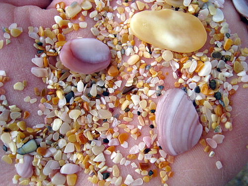
Spent a good half of the day exploring Matai Bay which turned out to be two twin coves – both absolutely beautiful with crystal clear water and nice fine sand. Similar to Matauri Bay at low tide the water line went way out and I got some beautiful photos. Lots of shells here too of course. The seashells here make me wonder why I ever picked up a shell in California... oh well.
Then off for our Cape Reinga trip, and the next post...
Back to Auckland for a Seatbelt
27May Thames to Ambury Park:
Let's see, woke up today and drove back around the Firth to Miranda to catch the shorebirds at high tide (that's the best time to see them.) We had some luck, but we were a little late for highest tide so the birds were further away form the shore. We had a nice walk through the mangroves though, and another nice chat with the gal from S. Africa who mans the desk at the centre.
After lunch on the beach, we headed up to South Auckland to run some errands – mainly to get the oil changed in the van. And we spent the night at a nice Auckland regional park called Ambury Park – in a paddock with sheep and cows.
28May Ambury Park to Wenderholm Park:
We spent the morning going to parts shops to find a replacement seatbelt for the van – the passenger side one has been on the fritz since we bought the van. We eventually found a used one in great shape for only $30 (they were $200 new), so we were happy and I no longer have to sit in the middle seat :) And the guy at the salvage yard gave us his card for when we want to sell the van... haha. Hopefully it will not come to that :)
After running some more errands in Auckland we drove north out of town and camped in another Auckland Regional Park – Wenderholm. It was in a nice location on the water, but too close to the main motorway – we could hear truck traffic all night.
Last 2 days in Coromandel (and Hot Water Beach)
25May
Fletcher Bay to Whitianga:
Today we woke up at beautiful Fletcher Bay and really didn't want to leave. This is at the northern tip of the Coromandel Penn with fantastic views of little islands and the Great Barrier Island in the distance, and steep green hills inland. The campground is surrounded by pasture and we had cows grazing around us all night. We saw the farmer zip by a couple times on a motorcycle and one of his dogs made friends with us - I'm sure the dogs get lots of handouts from campers in the summer! He was friendly, but VERY stinky - definitely living the dog's dream :)
We strolled on the bay again, and then started on the drive south back to Coromandel town. Fortunately the roads had dried out some, so we made better time - even though it's hard not to stop at every turnout to enjoy the spectacular views...
We stopped in the little town of Colville for lunch/brunch at the Colville Cafe. I had pancakes and bacon (the pancakes were almost crepe-like, very eggy) and Justin had a huge steak sandwich. Excellent :)
Then we headed for Driving Creek Railway and Pottery in Coromandel - a great place that encompasses the three passions of it's owner: a 3km long narrow-gauge railway, a pottery studio (with resident and visiting artists) and bush regeneration. If only I was a better potter, I would have applied to stay! The land is rich with terracotta clay and many of the potters dig their own, plus they have a variety of kilns - from standard electric ones to handbuilt brick kilns that are wood-fired... They had lots of great ceramic pieces decorating the place and plenty of tempting items for sale, but I resisted buying anything. We caught the next train-ride which was great fun. Over the past 20-30 years they have built 3km of track that zigzags up the mountain to a lookout tower at the top called the "Eyefull Tower". The train literally zig-zags up the mountain since it's so steep - there is an engine at both ends and the driver periodically stops, gets out, switches the track, and gets in at the other end. Plus several bridges and tunnels - lots of fun! The train goes through regenerating native NZ forest (bush) full of tree ferns and baby kauri and rimu. The ride takes about an hour and we really enjoyed it.
After that we headed out of town on the scenic 309 road that cuts through inland forests and has several points of interest including a waterfall and a few remaining old growth Kauri trees. The descent on the other side was scary though as the road was horribly muddy, narrow, and very curvy. We made it down though...
We spent the night at a holiday park south of Whitianga with a parrot collection – more on that later :)
26May
Whitianga to Thames:
Woke up at the holiday park and toured the Bird Park next door. A great collection of parrots plus many fancy game birds. I could have spent hours here talking to the birds :)
Then we drove through Whitianga to run some errands (groceries) – a very touristy town with a lot of new housing developments... we were unimpressed, and then off around the coast to explore some beaches. First stop the “Ferry Landing” - directly across the harbour from Whitanga with some great views and the ruins of a Maori Pa site – the site of a strategic fort that once guarded the harbour. Next stop the very beautiful walk to Cathedral Cove, with stops along the way at a couple other coves. Cathedral Cove is the highlight though, because at low tide you walk through an archway to get to the beach (see the pics). And the views are magnificent. Oh and this was where we encountered our first tour-bus load of twenty-something tourists. It was like a college-dorm reality show, with girls in heels hiking to the beach and hipster boys ogling them. We are SO GLAD we did not try to get around NZ on a tour bus...
And lastly we went to Hot Water Beach, which wasn't very hot! This is a beach with a hot thermal spring bubbling up in the sand and at low tide you can usually dig a hole in the sand and have your own hot tub. But today the low tide was not very low, and the ocean was rough due to a storm so to feel the hot spring you had to stand nearly waist deep in the COLD ocean, and only your toes would be warm. If you let your toes sink into the sand they would actually burn – so I'm sure it would have been nice and warm if the conditions had been better. Oh well :)
After that we drove back across the penninsula to spend the night at a holiday park in Thames.
Subscribe to:
Posts (Atom)