
day 1 photo set
Wednesday begins a bit chilly and slightly overcast. Christina and I rustle up breakfast - eggs, cereal, and toast, and coffee - while we make a list of all the items to pack for the tramp. After cleaning up, we quickly stuff all of the necessary camping gear into our packs:
1 tent and associated stakes and such
2 sleeping bags
2 thin inflatable pads
a change of clothes apiece, plus extra socks.
fleece jackets and rain coats, plus rain pants.
chaco sandals
camp stove and 2 fuel canisters
food for 3 days
3+ liters of water and water filter
toiletries and camp shovel
maps and guidebooks
two cameras
(etc.)
Our packs are now considerably heavier than anything we've ever hiked with before, but we shoulder them on and head up to the Waitiki Landing office to catch our ride. It's a few minutes after 10am, and no one is in the office. A moment after we get there, a Maori lady pops out from the adjacent fuel station/quick-stop and tells us that she's to drive us to our drop-off point today, but asks us to wait for a minute while she grabs some belated breakfast. Breakfast today is apparently a bag of crisps, a microwaved "hot pocket", and a large mug of tea with milk. Within 10 minutes, the man whom we originally arranged the trip with drives up in a 4WD van and we clue in to the fact that she is his wife. He agrees to take us straight-away in order to speed up matters.
Our ride to the drop-off point is uneventful. We heave our packs in the back of the van and are soon speeding out towards the west coast at a rather startling rate. After a kilometer or so on pavement, we skid onto a muddy, potholed gravel drive and continue without loss of speed around blind corners, over 1-lane bridges, and on the edge of sharp drop-offs - sometimes in our lane, sometimes in the middle of the road, depending on what is necessary to make the next turn without slowing down. Only the appearance of a fully-loaded logging truck - both trailers sagging under its cargo of pine - barrelling towards us over a 1-lane bridge occasions a full stop on our part.
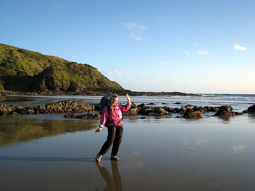
15 minutes and we we reach the drop-off point at the end of a muddy track. Between us and the Tasman Sea are a few kilometers of tall sand dunes, cut through by Te Paki stream, the shallow, sandy river that constitutes the first part of our hike. Our driver wishes us well as we reclaim our packs, promises to pick us up in 4 days time, then zips off to whatever task awaits him. We make use of the nearby DOC long drop, put on our sandals and roll up our pants. Meanwhile a local woman shows up in a van and sets up shop, waiting for the off-season sand-surfing enthusiast. It's the first I've heard of the sport, but Christina informs me that it's popular in NZ to rent body-boards and ride down the sand dunes.
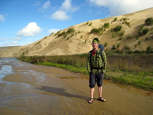
The day is still moderately sunny, but within half an hour of our start, blue-gray clouds begin rolling in from the west. I begin to regret my decision not to purchase a pack cover. We continue walking very slowly, slogging through the shallow water and saturated sand, trying to figure out how to best adjust our pack straps. To our north, the sand dunes continue out of sight. To our south and east, the dunes are bordered by rolling green hills. It's still a pretty day, but the original strong breeze is now turning rapidly into a serious headwind. A gentle rain begins to fall. At the point, the wide, shallow stream is little more than a set of intersecting rivulets, perhaps 20 meters wide, criss-crossing the flat sand towards the ocean. We meet a car driving upstream; its inhabitants wave cheerily at us as it passes. We ponder its fate in the heavier, less stable sand upstream and mentally wish them luck. Looking back as they pass, we see from the paint job that it's a rental car, so whoever is driving it has been doing their best to ignore the clause in all rental vehicle contracts which forbids you from driving on 90-mile beach. According to what we've been told (again and again), vehicles quite regularly get stuck in the sand and then dragged under by high tide.
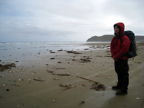
As we come around a curve and into sight of the Tasman Sea, the rain begins to fall more steadily. We trudge on, but by the time we pass the last dune, we're walking in a downpour. At this point we realize the first lesson of rain gear, which is that you put it on *before* you are caught in the rain. We drag out our jackets and rain pants and weasel our already-soaked selves into them, then huddle behind the last sand dune for the meager shelter it affords from the wind.
Today we are lucky; the rain dwindles to a fine mist after perhaps only 20 minutes or so, and we sit amidst the beach-grass and gorse and eat half-squashed peanut butter and jelly sandwiches.
Lunch concluded, we set off north along 90-mile beach. The sky is still thick with clouds, and periodically the heavy mist turns into light rain, but never into the sort of downpour just experienced. To our west the Tasman Sea roars and crashes onto the sand. It's a far cry from the gentle waves we saw just a few days ago at Matauri Bay. The beach is littered with shells, driftwood, kelp, the occasional dead fish, and small bits of the kind of industrially-manufactured flotsam you find on every beach - plastic bottles, short lengths of net, etc. The surf is loud enough to make conversation difficult, and for the most part we trudge northward in silence. Near the end of the beach, we are passed by a small truck heading north. It stops perhaps a kilometer beyond us and picks up someone, then turns around and passes us going back south. The driver waves cheerily and then we are alone. Behind us a great arch of rock to our south in the sea seems almost to be following us as we walk - closer one moment, then further away the next.
At the north end of the beach, the trail climbs up a very steep set of stairs for a few hundred meters, zig-zagging back and forth up the rock. We pause for a moment at its base to adjust packs and drink some water, then begin our ascent. This initial climb sets the pattern for our next few days, which is one of continual steep ascents followed by steep descents, punctuated by regular high ridgeline walks. It's a path designed to maximize spectacular views without any concern for one's legs or back. Out at sea, white-capped wave follows white-capped wave in unending succession.
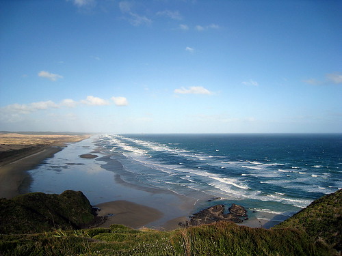
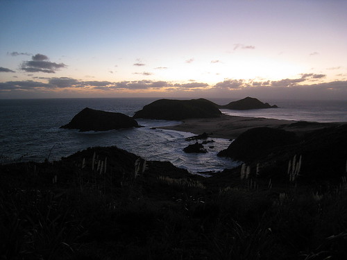
From the top of that first headland we look out and around the world. To our north and west lie the Tasman /Sea, crashing on the shore of Twilight Beach. To our east rises Cape Maria van Dieman and beyond that Cape Reinga. To the immediate south lie rolling half-grassy dunes such as we have been paralleling on our walk northward. The southeast, incourogously, is all gentle green hills dotted with sheep and cattle. It's mid-afternoon, and we still have a long way to go.
Before we start forward again into the brush, we note a pair of figures slowly toiling down the beach, perhaps half an hour behind us. Walking through the brush is not really that exciting. When you can't see very far ahead or behind you, and when the view to either side is blocked, points of interest are limited. The birds seem to agree. Either it is the universal naptime or anything which can fly aside from a few bugs has left for more stimulating environs. Periodically we emerge from brush near the top of some hill and gaze out at the ocean, only to lose it moments later as we plunge down 50 hard earned meters of altitude. It's obviously rained recently, for the whole track is muddy. The lowest spots are actually car-sized mudholes, and squeezing by these is difficult, since the woody brush is thick enough to prevent easy passage. Perhaps with a chainsaw it might be straightforward, but not without. Here and there the undergrowth becomes thicker. Frequently these spots are accompanied by a musky stench which I suppose must be wild pigs, as the path is punctuated by torn-up patches of earth where something has been rooting and digging..
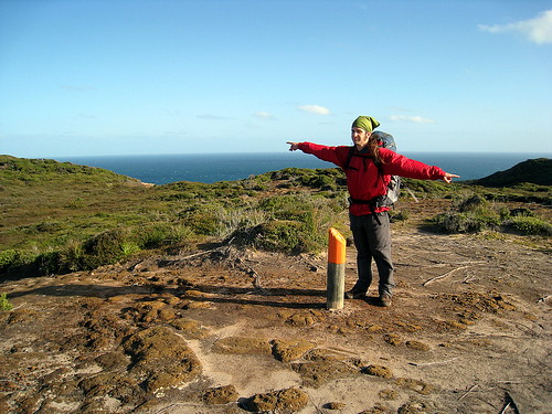
The brush we are walking through is criss-crossed by tracks. Whenever ours intersects with another track, an orange marker points out the correct direction.
Some of the other trails look enticing, but without a map, navigation in brush several feet taller than our heads seems like a bad idea. The track we are walking on at some points was obviously some sort of rough driving track, but it's been years since anything larger than a quad-bike has driven this way. The gullies and crevices which cross the narrow track would bog down anything larger.
An hour or so into the brush, we are ready for a break. It's very humid and still, and in the middle of the day we are nearly drowning in our own dank sweat. Shrugging off our packs and collapsing on the trail, we munch on peanuts and chocolate. There is really no other place to sit other than the least wet patch of muddy rock, and at this point we don't care. In a minute, the sound of voices becomes audible, and the young couple who must have been trailing us back on the beach comes around the corner. They smile, say hello, and carry on. We wish them well, then glance at their cheery faces and lightweight packs as they pass. How are they getting by? Perhaps it's all cold dehydrated food for them on this tramp, or maybe they're just in for a day, or maybe they don't feel the need to carry the kitchen sink on their backs around NZ.
After a few more minutes we struggle to our feet, adjust our pack straps for what seems like the millionth time, and set out. Shortly thereafter we are rewarded with a grand view to the southeast over the verdant texture of the bush-coated hills and a sight of our trail looping down towards Twilight Beach, which marks the official end of our first day's tramp. A bit heartened, we stomp down over the eroded track - which at this point was definitely at one time a rough bush road - and towards the beach. Having come out of the shadowy, overhanging scrub and buoyed by a bit of sunshine and receding claustrophobia, we decide if possible to push onward past the planned campsite and take the first of many water crossings.. It's nearing low tide, and according to the DOC brochure, we need to attempt this crossing within an hour either side of low tide.
Over a couple of hills and down we go! An hour passes and we reach the beach. It's sunny and beautiful in the waning daylight, and we trudge hurridly down the sand. Twilight Beach doesn't seem that long, but it's the described 45 minutes before we reach the east end. By this point, the sun hangs low on the horizon, casting blue and purple shadows on Cape Maria Van Dieman to our east. We wander about at the end of the beach and finally find the marker pointing the way up towards the official campground. If we'd only followed our noses, we would have known where to go, since the path off the beach is marred by a distinctly bathroom odor. Why the prior hordes of trampers all chose to pee so close to the track remains a mystery.
We climb up and up until we find the next set of signs. They mark the intersection between our tramp and another trail leading back towards the farmland to our south. We continue on, following the orange-topped posts which mark the path, and climb higher, passing the couple we met earlier. They are busy pitching their tent in the waning light, high up on a grassy protected meadow. Over one hill and another and then we are walking in the dusk. We've left behind the grassy hills and are now struggling across sand and eroded rock. The growing wind whips up the sand, and we stumble repeatedly, our feet caught by the immensely long runners of the grass which seems to be holding together this corner of New Zealand. The sky is dark, and in the twilight, the dunes and bluffs are that weird, barely-colored reddish-purple that meets your eyes before color vision gives up completely and the world turns gray.
Up again and we are walking behind a large sandy bluff, flashlight in hand, casting about for footprints or other signs of a trail. In the sand and on the rock, the only way to know you are on the trail is to see an orange marker at some random point ahead. A set of footprints is suggestive, but not a guarantee. Who knows where the person who made those was going? We persist until it's no longer possible to find another marker, then look for a place to camp for the night. The best we can manage is a spot behind a tiny, grass-topped hillock. It's the least-unlevel patch of sand in sight. We pitch the tent in darkness and wind, juggling flashlight and tent stakes, then crawl gratefully inside its shelter. Dinner is 2 packets of 'Pasta Carbonara', boiled hastily over our camp stove and shoveled down. Zipped into our sleeping bags, we fall asleep to the sussurration of the wind, the rustling of the grass above and behind us, and the endless crashing of the distant ocean.
3 comments:
Just reading this makes me exhausted. I hope the views have more than made up for the mud. =)
oh the views definitely made up for the mud! it was quite an adventure :) the mud just makes it more "memorable"
Few things that are really easy make for good stories. I'll remember Cape Reinga long after I forget some of the other places we've been.
Having said that, though, I must admit that I am glad not every day is quite as exhausting!
Post a Comment